Sezione di Bologna, main banner


Dipartimento Ambiente

ultimo aggiornamento: February 09, 2026


EnvITWC

Presso la Sezione di Bologna le attività nell'ambito del Dipartimento Ambiente riguardano principalmente oceanografia, rilevamenti ambientali e osservazioni geofisiche.

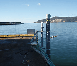
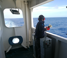
La Sezione è impegnata nell’implementazione e nel mantenimento di sistemi di monitoraggio nel Mar Mediterraneo basati su dati osservativi e su modelli di circolazione marina a diverse scale spazio-temporali.

Anche il livello del mare e la sua variabilità sono oggetto di studio e ricerca al fine di produrre modelli accurati per il tasso di innalzamento del livello del mare sia a scala locale che regionale e globale: questo infatti è uno degli indicatori diretti del cambiamento climatico in corso. Un focus particolare è dedicato agli effetti del cambiamento del livello del mare sulle aree costiere.

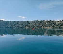
Nell’ambito dei rilevamenti ambientali la Sezione esegue campagne di monitoraggio della qualità dell'acqua del Lago Albano, con particolare attenzione alle emissioni endogene (misure di CO2, CH4 e temperatura).

Presso la Sezione si eseguono inoltre studi utilizzando tecniche di telerilevamento multiscala, con un focus particolare su liquefazione, subsidenza, deformazione, metodi di analisi, modellazione e osservazione.

Le attività di rilevamenti ambientali includono inoltre lo studio di emissioni dovute alla presenza di idrocarburi nel sottosuolo che derivano dall'intrappolamento e maturazione di sostanza organica nella crosta terrestre.

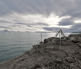
La Sezione è coinvolta in osservazioni geofisiche per la valutazione della perdita di massa di ghiaccio presso il fiordo Wholstenholme - Groenlandia: tramite un approccio multidisciplinare si intende studiare congiuntamente serie temporali di misure sismiche e di livello marino per stimare la massa di ghiaccio che si distacca dai grandi ghiacciai di sbocco.

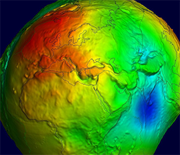
Nell’ambito della Geodesia Fisica, la sezione si concentra sullo studio del campo di gravità terrestre tramite osservazioni terrestri e satellitari.


Le aree di ricerca sono raggruppate nelle seguenti tematiche:


A federated European FAIR and Open Research Ecosystem for oceans, seas, coastal and inland waters
https://blue-cloud.org/

Dipartimento: Ambiente
Responsabile: Simoncelli

Study of multiple drivers of the North ATlantic decadal climate variability in a large ensemble of Century-long (1866-2015) historical Ocean ReAnalyses (NAT-CORA)
N/A

Dipartimento: Ambiente
Responsabile: Simoncelli

Aqua Research Infrastructure Services for the health and protection of our unique, oceans, seas and freshwater ecosystems
https://trimis.ec.europa.eu/project/aqua-research-infrastructure-services-health-and-protection-our-unique-oceans-seas-and

Dipartimento: Ambiente
Responsabile: Simoncelli

EMODnet Ingestion and safe-keeping of marine data
N/A

Dipartimento: Ambiente
Responsabile: Fratianni

GEOTWINS Digital Twin Components for Deep Geothermal Energy Power and Heat Generation
N/A

Dipartimento: Ambiente
Responsabile: Passarelli

ACCORDO DI COLLABORAZIONE NELL’AMBITO DEL PROGETTO CONGIUNTO PNRA0000060 “ICEGIANT - Integrated geodetic, geophysic and remote sensing observations for the study of David Glacier Cauldron icefall and the floating Drygalski ice-tongue”
N/A

Dipartimento: Ambiente
Responsabile: Danesi

PNRA19_00093 “East Antarctic International Ice Sheet Traverse (EAIIST)-phase 2”
https://www.pnra.aq/it/project/717/east-antarctic-international-ice-sheet-traverse

Dipartimento: Ambiente
Responsabile: Salimbeni

We provide a dataset of 3D coordinate time series of 37 continuous GNSS stations installed on onshore and offshore industrial settlements along a NW-SE-oriented and ~100-km-wide belt encompassing the eastern Italian coastal area and the Adriatic Sea. The dataset results from the analysis performed by using different geodetic software (Bernese, GAMIT/GLOBK and GIPSY) and is constituted by 6 raw position time series solutions (in ASCII pos format), referred to IGb08 and ITRF2014 reference frames.
https://doi.pangaea.de/10.1594/PANGAEA.914358

The REP_XBT_1999_2019 dataset comes from an improved and fully automatic quality control procedure applied to all available raw data and metadata from XBT probes samples and managed by ENEA S.Teresa Centre since September 1999 in the Ligurian and Tyrrhenian Seas. The reprocessed dataset contains a full metadata description obtained from the cruise reports according to the most recent community standards and formats. The version 2 is made available after the review process with new variables and changes in format.
https://progetti.ingv.it/it/progetti-dipartimentali/ambiente/macmap#rep-xbt-1999-2019

The datasets have been gathered during the monitoring campaigns of sea temperature in the Ligurian and Tyrrhenian Seas started in September 2021 within the MACMAP project in collaboration with ENEA and GNV S.p.A. shipping company. The data are collected using XBT probes along the Genova-Palermo track (MX04 line of the SOOP program of GOOS) using ships of opportunity. According to Simoncelli et al. (2024) a full metadata description, compliant with the most recent community standards and formats, completes the dataset.
https://progetti.ingv.it/it/progetti-dipartimentali/ambiente/macmap#datasets

Collection of meteo-hydrodinamic data - Wolstenholme fjord, Greenland. The dataset contains data acquired through a meteo-hydrometric station installed on August 2021 in Wolstenholme Fjord, Greenland
https://progetti.ingv.it/it/progetti-dipartimentali/ambiente/macmap#pituffik-station

The REP_XBT_1999_2019 dataset comes from an improved and fully automatic quality control procedure applied to all available raw data and metadata from XBT probes samples and managed by ENEA S.Teresa Centre since September 1999 in the Ligurian and Tyrrhenian Seas. The reprocessed dataset contains a full metadata description obtained from the cruise reports according to the most recent community standards and formats. The version 2 is made available after the review process with new variables and changes in format.
https://doi.org/10.13127/rep_xbt_1999_2019

arco temporale: 1999-2019

The PANAREA_SFO dataset includes chemical-physical data (temperature, pH, electrical conductivity, dissolved oxygen, pressure), besides the associated sensor metadata, recorded between June 2015 and December 2021 by the PEGASO multiparametric seafloor observatory. The observatory has been deployed over an area marked by an active hydrothermal system at a depth of about 25 meters, two miles off the east coast of Panarea. The target is to perform a long-term monitoring of the marine environment characterized by extreme conditions due to the venting of hydrothermal fluids. The high CO2 flow rate, temperatures up to 140°C, pH less than 3 and electrical conductivity higher than the sea-water, make that site a natural laboratory for a multidisciplinary approach to researchers focused on geohazards, geothermal resources and oceanographic sciences.
https://progetti.ingv.it/it/progetti-dipartimentali/ambiente/macmap#panarea-sfo

arco temporale: 2015-2021

The 60 years reanalysis has been produced by combining, every day, the output of the ocean model, forced by atmospheric surface fluxes and relaxed to SST, and quality controlled ocean observations. The hydrodynamics are supplied by the Nucleos for European Modelling of the Ocean (NEMO), with a variational data assimilation schema (OceanVar) thanks to which salinity and temperature profiles and satellite Sea Level Anomaly along track data are jointly assimilated to estimate the initial condition for numerical ocean model. The model horizontal grid resolution is 1/16° (ca. 6-7km) and the unevenly spaced vertical levels are 72. It spans the time period 1955-2015 and it is yearly updated.
https://www.cmcc.it/mediterranean-sea-rr-1955-2015

arco temporale: 1055-2015

The SDC_MED_DP2 product contains sliding decadal temperature fields for the Mediterranean Sea in the layer 0-2000m covering the time period 1955-2018 and OHC annual anomaly estimates for the 0-700m and the 0-2000m layers. Annual Temperature climatological fields were obtained from an integrated Mediterranean Sea dataset which combines data extracted from SeaDataNet infrastructure () at the end of July 2019 and the Coriolis Ocean Dataset for Reanalysis (CORA 5.2, accessed in July 2020) distributed by the Copernicus Marine Service (INSITU_GLO_TS_REP_OBSERVATIONS_013_001_b). The analysis was performed with the DIVAnd (Data-Interpolating Variational Analysis in n dimensions), version 2.6.1.
https://sextant.ifremer.fr/record/504ea4ee-abee-4ebf-ab89-c4200e1cdad4/

The SDC_GLO_CLIM_TS_V1 product contains two different monthly climatologies for temperature and salinity, SDC_GLO_CLIM_TS_V1_1 and SDC_GLO_CLIM_TS_V1_2 from the World Ocean Data (WOD) database. Only the basic quality control flags from the WOD are used. The climatology, V1_1, considers temperature and salinity profiles from Conductivity Depth Temperature (CTD) profilers, Ocean station data (OSD) and Moored buoy data (MRB) along with Profiling Floats (PFL) from 1900 to 2017. The climatology, V1_2, utilizes only PFL data from 2003 to 2017. V1_1 considers depth layers from surface to 6000 m while V1_2 only from 0 to 2000 m. The gridded fields are computed using DIVAnd (Data Interpolating Variational Analysis) version 2.3.1.
https://sextant.ifremer.fr/record/f632d0d4-3373-43a4-a6be-d2109ebe0177/

The MyOcean-CMEMS Mediterranean Sea reanalysis (MEDREA) system developed by INGV comprises an Ocean General Circulation Model based on Nucleos for European Modelling of the Ocean (NEMO version 3.2-3.4) code and a variational data assimilation scheme (OceanVar) for temperature and salinity vertical profiles and satellite SLA along track data. ERA-Interim atmospheric reanalysis data from ECMWF have been used to compute the air-sea fluxes. The model horizontal grid resolution is 1/16˚ (ca. 6-7 km) and the unevenly spaced vertical levels are 72. The initial data set covered the time period 1987-2013 and it is has been yearly updated up to year 2018 within the framework of CMEMS Med MFC.
https://www.cmcc.it/mediterranean-sea-physical-reanalysis-cmems-med-physics

Pialassa Baiona is a temperate coastal lagoon connected with the Northwestern Adriatic Sea (44° 280 N and 44°310 E). Sediment cores and surface sediments were collected in two habitats within Pialassa Baiona: a) a salt marsh habitat characterized by the presence of saltmarsh vegetation, and b) a human impacted habitat close to anthropogenic source inputs. Cores were sampled by inserting one cylindrical Plexiglas hand corer (5-cm diameter, 50 cm long) into the sediment to a depth of 20-25 cm, and surface sediment samples (0–5 cm) were collected with a stainless-steel grab sampler. The cores were extruded in the field, sectioned into 1‐2 cm intervals, and analyzed for total organic carbon (OC), total nitrogen (TN), carbon isotope ratio (δ13C) and dry bulk density (upper 20 – 25 cm) and analyzed for organic carbon (OC), total nitrogen (TN), carbon isotope ratio (δ13C) and dry bulk density. Organic carbon (OC), total nitrogen (TN), and carbon isotopes (δ13C = [(13C/12C)sample/(13C/12C)standard − 1] × 1,000) were measured in sediment cores and surface sediments using a using a FINNIGAN Delta Plus XP mass spectrometer directly coupled to Thermo Fisher FLASH 2000 CHNS Elemental Analyzer. OC and TN content was expressed as the weight percentage of dried sediment, and carbon isotope results were reported in the standard delta notation with respect to the Vienna Pee Dee Belemnite. A ‘three-end member’ mixing model was used to estimate the relative contribution of the different organic matter (OM) sources: marine phytoplankton (FM), riverine-estuarine phytoplankton (FRE), and C3 saltmarsh plant material (FSM): δ13Csample = δ13CM x FM + δ13CFE x FFE + δ13CSM x FSM C/Nsample = C/NM x FM + C/NFE x FFE + C/NSM x FSM 1 = FM + FRE + FSM where FM, FRE and FSM are the relative contributions of marine phytoplankton, riverine-estuarine phytoplankton, and saltmarsh plant material, respectively. δ13CM (-18.97‰) and C/NM (4.95), and δ13CRE (-30.70‰,) and C/NRE (6.63) represent the end member POC signature recorded during distinct marine and estuarine phytoplankton blooms in the coastal lagoon (Guerra et al., 2013).The C3 saltmarsh plant end-member was selected on the basis of typical δ13CSM (-20.2‰) and C/NSM (15.35) values for Juncus spp. (Gebrehiwet et al., 2008; Hughes and Sherr, 1983; J. I. Kelleway et al., 2017; Kemp et al., 2012, 2010; Lamb et al., 2006). References Gebrehiwet, T., Koretsky, C.M., Krishnamurthy, R. V., 2008. Influence of Spartina and Juncus on saltmarsh sediments. III. Organic geochemistry. Chem. Geol. 255, 114–119. Guerra, R., Pistocchi, R., Vanucci, S., 2013. Dynamics and sources of organic carbon in suspended particulate matter and sediments in Pialassa Baiona lagoon (NW Adriatic Sea, Italy). Estuar. Coast. Shelf Sci. 135, 24–32. Kelleway, J.I., Saintilan, N., Macreadie, P.I., Baldock, J.A., Ralph, P.J., 2017. Sediment and carbon deposition vary among vegetation assemblages in a coastal salt marsh. Biogeosciences 14, 3763–3779. Kemp, A.C., Vane, C.H., Horton, B.P., Culver, S.J., 2010. Stable carbon isotopes as potential sea-level indicators in salt marshes, North Carolina, USA. Holocene 20, 623–636. Kemp, A.C., Vane, C.H., Horton, B.P., Engelhart, S.E., Nikitina, D., 2012. Application of stable carbon isotopes for reconstructing salt-marsh floral zones and relative sea level, New Jersey, USA. J. Quat. Sci. 27, 404–414.
https://www.seanoe.org/data/00623/73534/

The EMODNET_NADR_CLIM_TS_V1 product contains Temperature and Salinity climatological fields for the Northern Adriatic Sea. Monthly and seasonal fields are released for periods 1955-2016, 1955-1984 and 1985-2016, while seasonal fields are provided for 6 decades: 1955-1964, 1965-1974, 1985-1994, 1995-2004, 2005-2016. The climatological fields were obtained from an integrated dataset in the Northern Adriatic Sea which combines data extracted from SeaDataNet infrastructure and the Coriolis Ocean Dataset for Reanalysis (CORA5.2). The analysis was performed with the DIVAnd (Data-Interpolating Variational Analysis in n dimensions), version 2.6.1. The horizontal resolution of the grid is 3km
https://progetti.ingv.it/index.php/it/contratto-ett-ingv#datasets

The dataset contains cone penetration test (CPT – electrical CPT, piezocone and seismic CPT) data from 2030 different sites across the epicentral area of the 2012 Emilia Romagna earthquake. Most of the sites come from a more extensive dataset of geological-geotechnical subsurface investigations curated by the Emilia-Romagna Regional Administration including also the surveys from Seismic Microzonation Studies. The remainder of the tests not acquired from the Emilia-Romagna Regional Administration were obtained through research activities performed during the last 10 years (e.g. Amoroso et al., 2017; Amoroso et al., 2020; Minarelli et al., 2022; Di Buccio et al., 2023; Amoroso et al., 2024).
https://geodb.ingv.it/DSPSPemilia/


INGV_extended_logo

Contatti:
Telefono: 051 415 1411
PEC: aoo.bologna@pec.ingv.it
Privacy
Disclaimer
Codice Fiscale: 06838821004
Partita Iva: 06838821004
I contenuti pubblicati su queste pagine dall'Istituto Nazionale di Geofisica e Vulcanologia sono distribuiti sotto licenza Creative Commons Attribution 4.0 International License. © 2026