Sezione di Bologna, main banner


Dipartimento Terremoti

ultimo aggiornamento: February 09, 2026


quakesOneWC

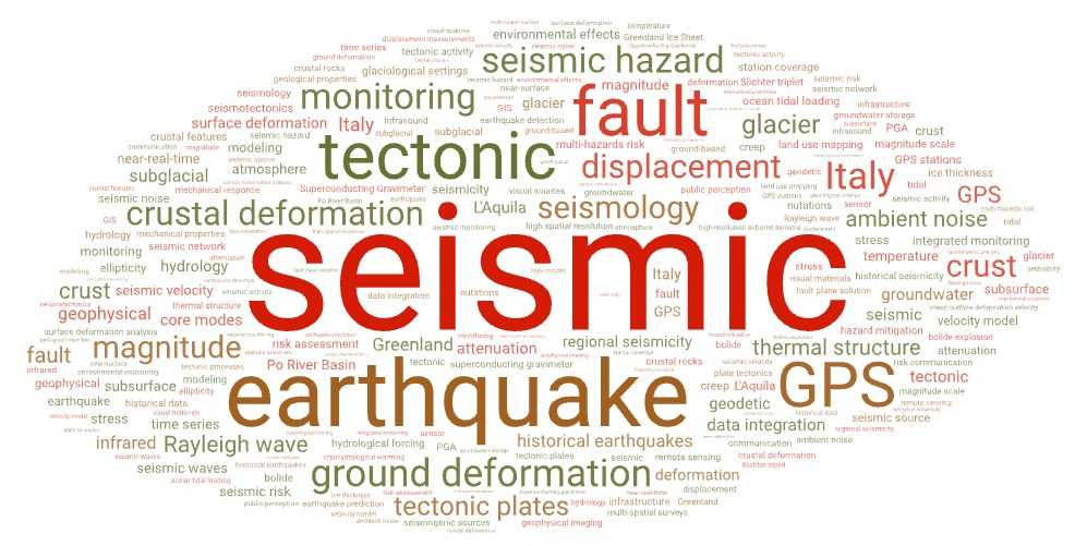
Il dipartimento Terremoti della Sezione di Bologna dell’INGV si dedica allo studio approfondito della Terra e dei fenomeni sismici. Con un approccio interdisciplinare, i ricercatori del Dipartimento si focalizzano su vari ambiti cruciali della geofisica e della sismologia con l’obiettivo di migliorare la comprensione dei processi geologici e di mitigare i rischi associati ai terremoti.

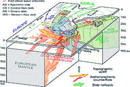
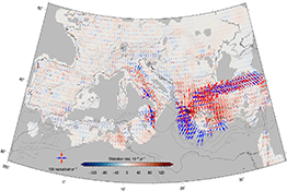
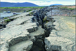
Le ricerche comprendono: lo studio della composizione e della struttura interna del nostro pianeta utilizzando tecniche avanzate di geofisica; la ricerca sulla deformazione crostale attiva, utilizzando dati GPS, misure di spostamento del suolo e modellazione geodinamica; l’identificazione dei meccanismi di rottura delle rocce lungo una faglia; lo sviluppo di modelli di rischio sismico per aiutare le autorità a prendere decisioni informate sulla gestione del territorio e sulla costruzione di infrastrutture resilienti; l’analisi di documenti storici e archeologici che offrono una prospettiva a lungo termine sui pattern sismici e sulle loro implicazioni future.

Il Dipartimento inoltre contribuisce all’analisi dei terremoti in tempo reale e ai protocolli di allerta tsunami, fornendo informazioni cruciali per la sicurezza pubblica del nostro paese.

Definition of a strategy to characterize historical ground motion based on archaeology, inventory of reconstruction, seismology and structural engineering
https://across-project.github.io

Dipartimento: Terremoti
Responsabile: Ciuccarelli

Convenzione tra l'Agenzia Regionale per la Sicurezza Territoriale e l'Istituto Nazionale di Geofisica e Vulcanologia per il supporto alle attività di protezione civile di competenza regionale di pianificazione e gestione delle emergenze relative al rischio sismico
N/A

Dipartimento: Terremoti
Responsabile: Pondrelli

Study of multiple drivers of the North ATlantic decadal climate variability in a large ensemble of Century-long (1866-2015) historical Ocean ReAnalyses (NAT-CORA)
N/A

Dipartimento: Terremoti
Responsabile: Salimbeni

Protocollo d'Intesa per l'esecuzione dell' Accordo Quadro per l'applicazione integrata degli Indirizzi e Linee Guida per il monitoraggio della sismicità, delle deformazioni del suolo e delle pressioni di poro (ILG) alle concessioni di coltivazione di idrocarburi denominate Val d'Agri e Gorgoglione in Basilicata
N/A

Dipartimento: Terremoti
Responsabile: Zaccarelli

Accordo Quadro per l'applicazione integrata degli Indirizzi e Linee Guida per il monitoraggio della sismicità, delle deformazioni del suolo e delle pressioni di poro (ILG) alla concessione di coltivazione di idrocarburi denominata Selva Malvezzi in Emilia Romagna
N/A

Dipartimento: Terremoti
Responsabile: Zaccarelli

A Scuola di Protezione Civile
N/A

Dipartimento: Terremoti
Responsabile: Ercolani

The Catalogue lists earthquakes that occurred in Italy between 461 B.C. and 1997, and earthquakes that occurred in the general Mediterranean area between the VIII century b.C. and the XV century. This version (CFTI5Med) features: the retrieval and formatting of over 23,000 original bibliographic documents, transcribed or printed, nearly 50% of those utilized in the CFTI5Med. These documents are now available on-line as fully searchable pdf files; a full geological reinterpretation, georeferencing and reprocessing of over 2,300 descriptions of earthquake-induced environmental effects, which are now all available and searchable in a user-friendly web-GIS environment; the elaboration of a number of texts and commentaries that were missing from the CFTI4Med version of the catalogue; a totally re-designed and more efficient web- and web-GIS interface. The new Catalogo dei Forti Terremoti in ltalia includes 1,259 earthquakes that occurred in Italy (98 of which are currently considered false). No commentaries on the main earthquake effects were available in the previous version of the catalogue for 87 of such events as they had not been updated with respect to the information supplied in Guidoboni e Comastri (2005) for the 1000 AD-1500 AD time interval. The commentaries concerning the most significant effects of Italian medieval earthquakes have now been elaborated and are available along with the information on more recent events. For the remainder of the earthquakes first presented with the CFTI4Med - those that occurred in the general Mediterranean area away from the Italian coasts - the new catalogue provides only the felt reports and basic epicentral parameters
https://cfti.ingv.it

The Advanced Laboratory of Historical Seismology (CFTILab), was designed with two distinct but complementary targets. The first target was to make available to a wide specialist and non-specialist public – scholars, civil protection officers, teachers, students, professionals, simple onlookers – the IT tools that today allow the analysis of the data provided by the Catalogue of Strong Earthquakes in Italy in its most advanced version, namely CFTI5Med (). In addition to making it possible to parameterize individual events, the various tools developed allow (1) the effects of different shocks that occurred in the same geographical area to be analyzed all at once, (2) the data proposed by different seismological databases to be compared, and (3) the large earthquake sequences of the past to be investigated in detail. The second target was to build a dynamic archive - and as far as possible an exhaustive one - of all that the Italian tradition of earthquake study has been able to produce. The CFTILab portal makes available all the materials that have been used for the elaboration of the Catalogue of the Strong Earthquakes in Italy, the numerous publications that resulted from the analysis of the catalogue data, the original historical sources, and a large archive of iconographic material, just to mention the main collections that the reader will find on the portal.
https://cfti.ingv.it

The CFTIlandslides, Italian database of historical earthquake-induced landslides by Istituto Nazionale di Geofisica e Vulcanologia (INGV), was developed within the project “Multi-scale, integrated approach for the definition of earthquake-induced landslide hazard in Italy”, funded by the Italian Ministry for the Environment, and completed in 2022. The goal of the project was to develop a multidisciplinary approach for assessing the earthquake-induced landslide hazard at national, regional, and local scales, combining existing databases and integrating them with the results from previous projects and research activities. The main objective was the investigation of the central Apennine region. One of the main scopes of the project was locating more accurately all recorded landslides. To this end we focused on the review of historical sources - either newly found or already archived in our database - and on the analysis of scientific articles and technical reports. In summary, our working group reviewed and integrated data relating to historical earthquake-induced landslides that were already included in the CFTI5Med. The combination of the relatively frequent seismic release with a very high landslide susceptibility, makes the Italian territory especially prone to the occurrence of earthquake-induced landslides. For this reason, over the past two years we continued our activity by reviewing all events included in the CFTI5Med for which landslide effects were reported, then we broadened the investigated area to the entire Italian territory.
https://cfti.ingv.it

è il gruppo di emergenza dell’INGV, ma operativo almeno dal 2009, con le competenze per: coordinare e svolgere campagne di monitoraggio per studi di risposta sismica locale a seguito di eventi sismici di forte magnitudo, o che comunque abbiano dato luogo a un danneggiamento imputabile anche all’amplificazione del moto sismico in superficie; svolgere attività propedeutiche alla microzonazione sismica in fase di emergenza nell’ambito del a cui l’INGV aderisce. Le attività di EMERSITO sono regolate dal suo . Il personale partecipante a EMERSITO ha professionalità ed esperienza in studi di risposta sismica locale e nelle attività propedeutiche alla microzonazione sismica, contribuendo all’insieme degli interventi in emergenza. Durante le nel territorio nazionale, EMERSITO si coordina con l’Unità di Crisi e con le altre
http://emersitoweb.rm.ingv.it/index.php/it/

arco temporale: 2009-2020

EIDA Italia offers data collected in realtime from the listed seismic networks. Seismic stations metadata are available by this page and by INGV web services (webservices.ingv.it). We distribute raw seismic and accelerometric data, after a quality check phase. Most of the data is integrated with offline data flows trying to cope with real time transmission problems. Seismic stations are usually installed in quiet places, with low seismic noise, far from human activities and with diverse connectivity characterized by different availability grades. Some seismic stations, especially if installed during a seismic emergency, may suffer from poor transmission links in realtime. Archived data can be integrated a posteriori with data locally archived, when available. Data versioning of data is not currently available in EIDA.
https://doi.org/10.13127/sd/fqwsu1k6ib

SISMIKO è il gruppo di emergenza istituito formalmente nel 2015 con Decreto del Presidente dell'INGV, ma operativo già dal 2009, che prevede il coordinamento a livello nazionale delle Reti Sismiche Mobili di Pronto Intervento in emergenza. SISMIKO ha l’importante compito di installare, nel più breve tempo possibile, stazioni sismiche temporanee al fine di incrementare la densità delle reti permanenti presenti in un’area colpita da una emergenza sismica o vulcanica. L'integrazione di reti permanenti e temporanee aumenta sensibilmente la capacità di detezione dei terremoti e la qualità delle loro localizzazioni, consentendo nell'immediato di definire con maggiore precisione e accuratezza il fenomeno in corso e fornendo dati di ottima qualità per studi successivi di sismotettonica e fisica del terremoto. SISMIKO è un gruppo operativo trasversale dell’INGV cui partecipano, su base volontaria e secondo le proprie competenze professionali, tecnici, tecnologi e ricercatori afferenti alle diverse Sezioni territoriali e che svolge la propria attività in autonomia scientifica e operativa attivandosi quindi sia per motivazioni di ricerca sia di servizio. Le attività di SISMIKO seguono un protocollo operativo e, in caso di emergenza sismica, sono svolte in sinergia con gli altri gruppi di emergenza EMERGEO, EMERSITO, QUEST e IES come previsto nel Protocollo di Ente per le emergenze sismiche e da maremoto. SISMIKO è guidato da un Comitato di Coordinamento costituito dai coordinatori nazionali e dai referenti di sede. Dal 2020 prevede anche la figura dei Consulenti ricoperta da ricercatori e tecnologi esperti in particolari settori o responsabili di servizi essenziali.
https://sismiko.ingv.it/

arco temporale: 2010-2024

Italy has a rich history of studies on seismic history within the country and surrounding areas. Numerous archives and databases that focus on historical earthquake data, primarily intensity observations, are regularly updated. Macroseismic fields of past earthquakes are of foremost importance for evaluation of earthquake effects. To this purpose, we have implemented a strategy for generating historical earthquake shaking maps by adopting the ShakeMap service provided by the Istituto Nazionale di Geofisica e Vulcanologia (INGV). For our analysis, we used this dataset which contains over 12,000 intensity observations collected from the Italian Macroseismic Database (DBMI15). We selected 79 earthquakes with a magnitude of 6.0 or higher that occurred before 1972. The resulting shaking maps have been available on the INGV ShakeMap portal and the ASMI (Archivio Storico Macrosismico Italiano, Rovida et al., 2017) platform. To build the dataset, we adopted the configuration defined for the seismic settings in Italy, as described in the work of Michelini et al. (2020). We employed customized ground-motion-to-intensity conversion equations (GMICEs) and intensity prediction equations (IPEs). The conversion between ground motion and intensity was conducted using the regressions developed by Oliveti et al. (2022) and implemented in ShakeMap.
http://shakemap.ingv.it/shake4/historicArchive.html

More than three decades of historical earthquake studies has produced many iconographic testimonies that may be used by scholars to gain further insight into the extent and economical value of the damage suffered. The type of images that emerged from specific research on the effects of earthquakes is very rich and varied: it includes drawings associated with damage assessment, engravings taken from real life drawings, prints, paintings, watercolors, mosaics, frescoes, and photographs. A class of its own, very valuable for the study of historical earthquakes, is the exact localization of earthquake effects on topographic maps; a type of source that allows the impact of specific major earthquakes to be displayed in great geographical detail.
https://cfti.ingv.it/visual/

Sotto l'acronimo QUEST si cela un Team di esperti dedicato al rilievo macrosismico e geologico post-terremoto in grado di agire in autonomia, con lo scopo di fornire, rapidamente ed univocamente, il quadro degli effetti nell'area colpita da un evento sismico, a supporto degli interventi di Protezione Civile e della Comunità Scientifica.
https://quest.ingv.it/rilievi-macrosismici?category_children=1&category[0]=1

arco temporale: 2000-2023

Quick Regional Moment Tensors, or QRCMTs, are centroid moment tensors computed rapidly after an earthquake occurred in Euro-Mediterranean region and with a magnitude at least 4.5. For Italy we lower this threshold to 4.0 when possible. The computation method is the same used to update RCMT European-Mediterranean Catalog (Ardvisson and Ekstrom, 1998; Pondrelli et al., 2011 and references therein). Starting from 2011, all QRCMTs solutions are published on this web page and included in the RCMT Web Search Page . A description of the procedure used for computation of QRCMTs can be found in Pondrelli et al., 2012 and 2016 (Annals of Geophysics, vol.55, n.4 DOI: 10.4401/ag-6146 and Annals of Geophysics, vol.59, Fast Track 5, 2016; DOI: 10.4401/ag-7240 respectively)
https://autorcmt.bo.ingv.it/quicks.html

arco temporale: 2011-2025

The NEAM Tsunami Hazard Model 2018 (NEAMTHM18) is a probabilistic hazard model for tsunamis generated by earthquakes. It covers the coastlines of the North-East Atlantic, the Mediterranean, and connected Seas (NEAM). In this online data product, the hazard results are provided by hazard curves calculated at 2,343 Points of Interest (POI), distributed in the North-East Atlantic (1,076 POIs), the Mediterranean Sea (1,130 POIs), and the Black Sea (137 POIs) at an average spacing of ~20 km. For each POI, hazard curves are given for the mean, 2nd, 16th, 50th, 84th, and 98th percentiles. Maps derived from hazard curves are Probability maps for Maximum Inundation Heights (MIH) of 1, 2, 5, 10, 20 meters; Hazard maps for Average Return Periods (ARP) of 500, 1,000, 2,500, 5,000, 10,000 years. For each map, precalculated displays are provided for the mean, the 16th percentile, and the 84th percentile. All data are also made accessible through an interactive web mapper and through Open Geospatial Consortium standard web services. The model was prepared in the framework of the European Project TSUMAPS-NEAM () funded by the mechanism of the European Civil Protection and Humanitarian Aid Operations (grant no. ECHO/SUB/2015/718568/PREV26).
https://tsumaps-neam.eu/neamthm18/

In the EPOS by the PON GRINT, will consist of 10 semi-permanent broadband seismic stations to record the seismic signals from the set of faults present in the area. The network began operations in spring-summer 2022. Access to data will be free to stimulate wide-ranging applications. For info: , OR3 "Osservatori di Faglie Attive".
https://eida.ingv.it/en/network/XE_2022

The European Database of Seismogenic (EDSF) was compiled in the framework of the EU Project , Work Package 3, Task 3.2. EDSF includes only faults that are deemed to be capable of generating earthquakes of magnitude equal to or larger than 5.5 and aims at ensuring a homogeneous input for use in ground-shaking hazard assessment in the Euro-Mediterranean area. Several research institutions participated in this effort with the contribution of many scientists (). .
https://seismofaults.eu/edsf13

The Catalogue lists earthquakes that occurred in Italy between 461 B.C. and 1997, and earthquakes that occurred in the general Mediterranean area between the VIII century b.C. and the XV century. This version (CFTI5Med) features: the retrieval and formatting of over 23,000 original bibliographic documents, transcribed or printed, nearly 50% of those utilized in the CFTI5Med. These documents are now available on-line as fully searchable pdf files; a full geological reinterpretation, georeferencing and reprocessing of over 2,300 descriptions of earthquake-induced environmental effects, which are now all available and searchable in a user-friendly web-GIS environment; the elaboration of a number of texts and commentaries that were missing from the CFTI4Med version of the catalogue; a totally re-designed and more efficient web- and web-GIS interface. The new Catalogo dei Forti Terremoti in ltalia includes 1,259 earthquakes that occurred in Italy (98 of which are currently considered false). No commentaries on the main earthquake effects were available in the previous version of the catalogue for 87 of such events as they had not been updated with respect to the information supplied in Guidoboni e Comastri (2005) for the 1000 AD-1500 AD time interval. The commentaries concerning the most significant effects of Italian medieval earthquakes have now been elaborated and are available along with the information on more recent events. For the remainder of the earthquakes first presented with the CFTI4Med - those that occurred in the general Mediterranean area away from the Italian coasts - the new catalogue provides only the felt reports and basic epicentral parameters.
https://storing.ingv.it/cfti/cfti5/

The Mirandola anticline represents a buried fault-propagation fold which has been growing during Quaternary due to the seismogenic activity of a blind segment belonging to the broader Ferrara Arc. The last reactivation occurred during the May 2012 Emilia sequence. In correspondence with this structure, the thickness of the marine and continental deposits of the Po Plain foredeep is particularly reduced. In order to better define the shallow geometry of this tectonic structure, and hence its recent activity, we investigated in a depth range which is intermediate between the surficial morphological observations and seismic profiles information. In particular, we carried out numerous passive seismic measurements (single-station microtremor) for obtaining the horizontal-to-vertical spectral ratio. The results of a combined analysis of the peak frequency and its amplitude nicely fit the available geological information, suggesting that this low-cost geophysical technique could be successfully applied in other sectors of wide morphologically flat alluvial plains to investigate blind and completely buried potential seismogenic structures.The complete dataset of 131 measurements, with HVSR curve in jpg format and peak frequency and amplitude of the ratio H/V values, is here provided.
https://doi.pangaea.de/10.1594/PANGAEA.896394

We provide a dataset of 3D coordinate time series of 37 continuous GNSS stations installed on onshore and offshore industrial settlements along a NW-SE-oriented and ~100-km-wide belt encompassing the eastern Italian coastal area and the Adriatic Sea. The dataset results from the analysis performed by using different geodetic software (Bernese, GAMIT/GLOBK and GIPSY) and is constituted by 6 raw position time series solutions (in ASCII pos format), referred to IGb08 and ITRF2014 reference frames.
https://doi.pangaea.de/10.1594/PANGAEA.914358

We provide a database of the coseismic surface ruptures produced by the 26 December 2018 Mw 4.9 earthquake that struck the eastern flank of Mt. Etna (southern Italy), the largest active volcano in Europe. Despite its small size, this shallow earthquake caused an impressive system of coseismic surface ruptures extending about 8.5 km, along the trace of the NNW-trending active Fiandaca Fault. We performed detailed field surveys were performed in the epicentral region to describe the ruptures geometry and kinematics. These exhibit a dominant right-oblique sense of slip with coseismic displacement peaks of 0.35 m. The Fiandaca Fault is part of a complex active faults system affecting the eastern flank of Mt. Etna. Its seismic history indicates a prominent surface-faulting potential, so our study is essential for unravelling the seismotectonics of shallow earthquakes in volcanic settings, and contributes updating empirical scaling laws relating moderate-sized earthquakes and surface faulting. The collected observations have been parsed and organized in a concise database consisting of 874 homogeneous georeferenced records. The main features describing the coseismic ruptures are the following: ID, time of sample collection, location (latitude, longitude, elevation), type of rupture, type of affected substratum, attitude (dip angle, dip direction, strike), surface offset (opening, throw, strike slip, net slip), kinematics, slip vector attitude, width of the deformation zone.
https://doi.pangaea.de/10.1594/PANGAEA.904332

DBMI15 provides a homogeneous set of macroseismic intensity data collected from several sources, for Italian earthquakes with maximum intensity ≥ 5 in the period 1000-2020. Version 4 of DBMI15 contains 123981 macroseismic data points related to 3229 earthquakes. Macroseismic Data Points (MDPs) are collected and organized in DBMI for several scopes. The main goal is to create a homogenous set of data for assessing earthquake parameters (epicentral location and magnitude) for compiling the Parametric Catalogue of Italian Earthquakes (CPTI). The data provided by DBMI are also used for compiling the seismic history of thousands of Italian localities (15343 in DBMI15), in other words the list of effects observed in a place through time as a consequence of earthquakes, expressed as macroseismic intensity degrees.
https://emidius.mi.ingv.it/CPTI15-DBMI15/description_DBMI15.htm

The Italian Parametric Earthquake Catalogue (CPTI, Catalogo Parametrico dei Terremoti Italiani) represents the most extensive and reliable source of parameters for earthquakes in Italy and surrounding areas. CPTI15 is the fourth generation of the CPTI series, the first dating back to 1999 (CPTI99), and provides the most advanced and updated sets of macroseismic and instrumental data and parameters for Italian earthquakes with maximum intensity I ≥ 5 or magnitude Mw ≥ 4.0 in the period 1000-2020. The catalogue lists 4894 events, 70% of which have parameters based on the macroseismic datapoints provided by the Italian Macroseismic Database DBMI15. If available, both macroseismic and instrumental parameters are provided, together with a set of “preferred ones”, which consist of a selection between the macroseismic and the instrumental epicentres, and the weighted average of the macroseismic and instrumental magnitudes.
https://emidius.mi.ingv.it/CPTI15-DBMI15/

ZS9 is a seismic source model for Italy to be used as an input for country-wide probabilistic seismic hazard assessment (PSHA) in the frame of the compilation of the national reference map. ZS9 is made out of 36 zones where earthquakes with Mw > = 5 are expected. It also assumes that earthquakes with Mw up to 5 may occur anywhere outside the seismogenic zones, although the associated probability is rather low. Special care was taken to ensure that each zone sampled a large enough number of earthquakes so that we could compute reliable earthquake production rates. Although it was drawn following criteria that are standard practice in PSHA, ZS9 is also innovative in that every zone is characterised also by its mean seismogenic depth (the depth of the crustal volume that will presumably release future earthquakes) and predominant focal mechanism (their most likely rupture mechanism). These properties were determined using instrumental data, and only in a limited number of cases we resorted to geologic constraints and expert judgment to cope with lack of data or conflicting indications. These attributes allow ZS9 to be used with more accurate regionalized depth-dependent attenuation relations, and are ultimately expected to increase significantly the reliability of seismic hazard estimates.
http://zonesismiche.mi.ingv.it/elaborazioni/dati_di_ingresso/

ShakeMaps is a web page that provides near-time maps of ground shaking for M >= 3.0 earthquakes in Italy and neighbouring areas. The maps are available for the macroseismic intensity and 5 peak ground motions of engineering relevance (PGA, PGV, PSA0.3s, PSA1.0s, PSA3.0s). These maps are open to public access, and available in different formats as jpg, ps, XML and shapefiles. They are used by the Civil Protection Agency for post-earthquake response and recovery and preparedness exercises, and by public or private local organizations to retrive information about the impact of the earthquakes.
https://data.ingv.it/dataset/58#additional-metadata

This dataset is the result of a compilation of all centroid moment tensors computed for the Italian region for the entire period of availability of digital seismographic data, e.g. 1977 to present. It thus includes solutions from the Global CMT Catalog, from the European-Mediterranean RCMT Catalog, from several papers dedicated to these data (e.g. Pondrelli et al., 2006). In addition, the RCMTs computed for the NE Italy, Friuli, 1976 seismic sequence are included (Pondrelli et al., 2001). We make available a wide dataset covering nearly 40 years of seismic activity, more than 700 centroid moment tensors, for shallow and intermediate depth earthquakes, with magnitude between 4.0 to 6.9.
http://rcmt2.bo.ingv.it/Italydataset.html

The European-Mediterranean Catalog of RCMT includes the seismic moment tensor of earthquakes with a M>=4.5 occurred in this region since 1997 to present. This catalog is updated monthly, adding solutions for events occurred recently. Commonly, soon after an event of interest is computed a Quick RCMT. Some month later, the definitive solution is (re)computed and included in the Catalog. The creation of this Catalog in the Mediterranean region, where also moderate magnitude earthquakes have a great relevance in seismotectonic studies and not only, allowed the availability of 10 times the number of CMTs with respect to the only Global CMT catalog numbers.
http://rcmt2.bo.ingv.it/

An updated and homogeneous earthquake data set for Italy compiled by joining the Italian Macroseismic Database DBMI15 and the Engineering Strong-Motion (ESM) accelerometric data bank. The database has been compiled through an extensive procedure of selection and revision based on two main steps: 1) the removal of several earthquakes in DBMI15 because the data source has been considered to be largely unreliable in the estimation of the macroseismic intensities and 2) the extraction of all the localities reporting intensity data which are located within 3 km from the accelerograph stations that recorded the data. The final data set includes 519 recordings from 65 earthquakes and 227 stations in the time span 1972-2016. The events are characterized by moment magnitudes in the range 4.1-6.8 and depths in the range 0-55 km. Here, we illustrate the data collection and the properties of the database in terms of recording, event and station distributions as well as macroseismic intensity points. Furthermore, we list the most relevant features of engineering interest showing several statistics with reference to the most significant metadata (such as moment magnitude, several distance metrics, style of faulting etc).
https://zenodo.org/records/4623732

The AM(eri)GO project is a joint venture between Regione Marche-SPC and INGV. It aims at the dissemination of original information on the major earthquakes that have affected the Umbria-Marche region in the past centuries. With AM(eri)GO we give back to this territory an important portion of its history. Browsing through it, visitors will discover that earthquakes are recurring natural events that contributed to shape our towns and environment, and not merely unexpected disasters that always catch us unprepared.
https://doi.org/10.13127/amerigo.1

The provided dataset is a HOmogeneous catalog of Italian instRUmental Seismicity updated in near-real time. The magnitudes of all events are homogeneously revalued so that to be consistent with Mw standard estimates made by the Global CMT project. For the time interval from 1960 to 15 April 2005 it is obtained by merging catalogs and online resources available for the Italian area and homogenizing all magnitudes to Mw according to empirical relationships computed using the Chi Square Regression method which properly consider the uncertainties of both variables. From 16 April 2005 to present, an automatic procedure periodically downloads the data of the on-line bulletin of the Istituto Nazionale di Geofisica e Vulcanologia (INGV) and of online Moment Tensor catalogs from respective websites, merges the different sources and applies traditional magnitude conversions to Mw. The resulting dataset from 1960 to present is provided in two versions: HORUS_Ita_Catalog.txt where a random second decimal digit is added to ML and Md of the INGV bulletin (ISIDe) before computing Mw proxies, and HORUS_Ita_Catalog_o.txt where the original ML and Md are used to compute Mw proxies (Lolli et al., 2020, under revision).


The 2016–2017 Central Italy earthquakes have shown that the local seismic risk is dominated by the extreme vulnerability of the building stock. We attempt to rank the vulnerability of Apennines' settlements based on a combined geological-historical approach. We first discuss the reasons of the apparent paradox caused by the very different seismic response of Amatrice and Norcia, both strongly hit by the 24 August 2016 earthquake (Mw 6.0). Based on the awareness that strong earthquakes force building reconstructions and changes in the individual and societal perception of seismic risk, we assume that the global vulnerability of Italian settlements increases with time since the last significant earthquake. We focus on the very active seismogenic areas straddling Italy's Apennines. We then use data on the local seismogenic sources and earthquake history to (1) select the municipalities that are more likely to suffer from destructive ground shaking, and (2) rank them as a function of the time elapsed since the latest earthquake, i.e. in terms of increasing vulnerability. We hence identified 716 municipalities, totaling about 5% of the Italian population, over 50% of which have not experienced destructive shaking since 1861, when the Kingdom of Italy reunited a number of smaller states. As such they are primary candidates to a poor performance in future significant earthquakes (Mw > 5.5) and should be given priority in any statewide vulnerability reduction plan. All results and elaborations, including the seismic histories of each of the selected localities, are also supplied in this specifically designed web-GIS.
https://cfti.ingv.it/vulnerability/

The network is composed of 6 temporary seismic stations around the artificial reservoir of Monte Cotugno (Basilicata, Italy) that integrate the regional permanent network of the area. The main goal of the experiment is to record and study micro-seismicity, for the identification of possible reservoir-induced effects. The instruments used for the experiment are (a) Nanometrics Trillium Compact 120s broadband sensor connected to Reftek C130 datalogger, and (b) SARA SS10 sensor connected to Reftek 72A datalogger. All the instruments have acquired data in continuous mode at a sampling rate of 100 Hz.
https://eida.ingv.it/en/network/3S_2021

INGV_extended_logo

Contatti:
Telefono: 051 415 1411
PEC: aoo.bologna@pec.ingv.it
Privacy
Disclaimer
Codice Fiscale: 06838821004
Partita Iva: 06838821004
I contenuti pubblicati su queste pagine dall'Istituto Nazionale di Geofisica e Vulcanologia sono distribuiti sotto licenza Creative Commons Attribution 4.0 International License. © 2026